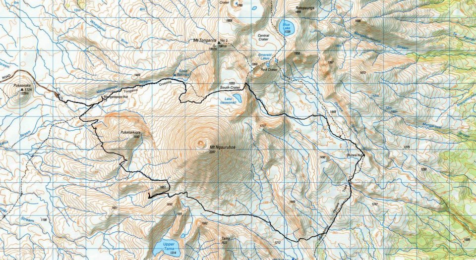
"Andrew Shelley and I are doing the following route on Wednesday 11th January. Starting at Mangatepopo carpark up to South Crater, drop down into Oturere (cross country), Northern Circuit trail across Rangipo Desert, cross country around the Southern side of Ngauruhoe to join un marked trail back to Mangatepopo Valley.
Social/Run/Walk/Crawl/or Grovel what we can!! Let me know your thoughts :)
Time TBA."
As founder of the group, this was the first outing posted that I was available for and it sounded very interesting, especially as I was entered in the Tussock Traverse a couple of weeks later. So after a bit of to and fro everything was settled and even the weather came to the party with the first fine day in about 10 days.
So we met at the start of the Tongariro Crossing at 9am, bright-eyed and bushy-tailed and ready to take on the world - well this small part of it anyway. Planned time, about 7 to 8 hours... well that was the plan!

Lot's of others doing the Crossing that day, with it being the first fine day in a while, but we started out at a steady jog passing many as we went. We stopped early on at the Mangatepopo Hut for Andrew to fill in the Log Book as we were going 'off-trail'.
I was very surprised at the quality of the Crossing track, it was more like a 4-lane highway with wide trails, boardwalks and the runners favourites... steps!
There are plenty of steps, as those who have done the Crossing will know. But we set a pretty good pace, working our way past trekkers from all over the world, stopping for our first food break just shy of the top of the steps.

We worked out way up to South Crater and a bit above - about a 600m climb - on this great walkway... then the fun started. We just went down the cliff on the right side of the trail - as you do!
The picture at left show Andrew and Heather descending from the trail into the valley, you can see how careful they are being, firstly because it was quite soft and loose and secondly (and probably more importantly) it was bloody steep!

At least at this stage we thought it was steep, we encountered worse later... but that can wait for now. We made it down to the bottom with no drama and were rewarded with the fabulous view back to where we had come from, with small figures still on the trail just visible (pic left).

This bit of cross-country was fabulous, we avoided the natural plants as much as possible and the going was great with us able to jog steadily for most of the way surrounded by the scenery direct from Lord of the Rings.
Andrew had entered waypoints on his Garmin for the expected route and we worked our way towards the first waypoint and straight onto the Northern Circuit Trail - exactly where he expected it.
 We followed this trail to the Oturere hut where we stopped for more food and drink and for Andrew to enter the info in the Log Book.
We bumped into 3 blokes doing the Northern Circuit here who happily took our picture... they were the last people we encountered for about the next 8 hours. We left on the Northern Circuit Trail and proceeded at a good pace with a few climbs and descents thrown in and having an absolute ball!


When the time was right, Andrew's waypoints told us it was time to leave the trail again for the traverse across the saddle next to Ngauruhoe and back to the start. Somewhere around here things went ever so slightly wrong....
We went down the next valley and started traversing around the corner on some rather tricky side slope. We passed a post on the top of one of the crests and headed off down the other side of the crest... for quite a way. At this stage we did what all blokes should do and listened to the 'gut-feelings' of the only lady in the group. Heather didn't feel we were in the right place and that maybe we should back-track a bit.
And a good decision it was, we back-tracked to a saddle down further South, expecting to be able to slide through the saddle into the correct valley. We got to the saddle and straight away could see where we should have gone... but there was no way we could get down into the valley without a parachute or a helicopter!.
So now what? rather than head several km's back in to direction we had come from and then climb back into the correct valley... we decided to head on up and try to traverse around the range keeping as high as we could above the vegetation line. This worked really well for a while.... even when we first hit the vegetation it was mainly mosses and ankle-height scrub and was no problem... until we got around to the north-facing side.
That was a double-edged sword... we got to the northern slopes and the first thing we could see was the carpark, clear as a bell a few km's away as the crow flies. Unfortunately we were not crows and there was now some serious undergrowth between us and the carpark.
Time to 'Bush-Bash'... well, that was an experience I am not in a hurry to repeat. Undergrowth so thick that we often couldn't see the ground - I disappeared down a couple of holes - so thick that we had to stay in sight of each other. We climbed through, over, under and around heavily intertwined scrub for what was probably only 400-500 metres and took longer than a 10km training run.
At the bottom of the hill when we finally made it the going was quite a bit easier - but not easy as such - and we worked our way along next to the stream and then up the hill on the other side, which, being south facing, was not as thick.

At the top of this hill it looked like we had one more downhill through the thick stuff and I was just investigating potential routes when Andrew discovered a trail, old and not much used recently, but definitely a trail. This lifted spirits and away we went down to where it met up with the trail from the Tongariro Crossing trail to the Chateau. You can see me celebrating at right!
After that it was a simple walk back up the trail, stopping at the Mangatepopo Hut to sign back in and head to the carpark... 10 hours and 47 minutes after we started.
As with all such excursions... once finished it became an adventure! I can truly say that although we at times struggled through some very very difficult terrain, I never felt in danger. We had phones with coverage and with our Garmins we regularly contacted Paul Charteris who became our 'outside contact' with our position coordinates (thanks Paul). My only worry was the embarrassment if we had to be airlifted off... which fortunately did not happen.
We had adequate food and all the first-aid equipment, exposure blankets etc and clothing required and I would never venture into an unknown 'wild' experience without that equipment. The only thing that got tight was drink. I ran out with only 1.5L in my backpack and took a risk and took some water from a grassy stream. This is not the best solution, however I don't seem to have had any backlash and it is now 4 days later.
My companions were fantastic, Andrew has a cool calm head and Heather stayed pretty calm in a situation that none of us were comfortable with at times. We discussed options often during the trip and made decisions (not always the right ones) that seemed right at the time. You will notice that there are no pics on the second half of this story, as taking pictures stopped being a priority, however at the bottom are some more pictures from during the day, thanks to Andrew for some of these.
Now, looking back, I would not change a thing. I learned so much more from the mistakes we made than I ever would if we had cruised around with no problems. If it had all gone to plan we would probably have finished in a bout 7 hours and I would have decided that 'this cross-country stuff' is pretty easy. It's not, even the best of plans can go astray and I truly believe in the saying "what doesn't kill you, makes you stronger".
Thanks Heather and Andrew for a fantastic experience which will be one I carry with me and treasure for the rest of my lifetime.
Andrew's Blog


No comments:
Post a Comment